

Cyclone-Related Flooding: Inland Districts Face Serious Risks Even Away From the Coast

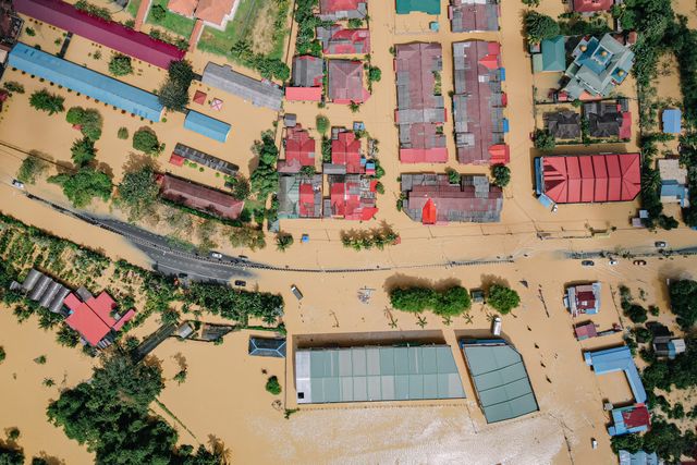

When a cyclone approaches or crosses a coastline, public attention often focuses on the areas expected to experience the strongest winds, storm surges and direct coastal damage. However, the danger does not end when the cyclone moves inland. In many situations, districts located hundreds of kilometres away from the coast can experience severe flooding, overflowing rivers, damaged roads, agricultural losses and disruptions to essential services. These impacts can continue even after the cyclone has weakened significantly.
Cyclone-related inland flooding occurs because tropical cyclones carry enormous amounts of moisture and can produce prolonged, intense rainfall over large geographical areas. As the storm moves inland, its rain bands may continue delivering heavy precipitation, while rivers, streams and drainage networks struggle to manage the additional water. The resulting floods can affect locations that have no direct connection with coastal storm surges.
India is particularly vulnerable because its river systems, monsoon conditions, varied terrain and expanding urban settlements create several pathways through which cyclone rainfall can produce inland disasters. A cyclone affecting Odisha, Andhra Pradesh, West Bengal or Gujarat may generate flooding risks not only along the coast but also across upstream and downstream river basins. Understanding these processes is essential because a district does not need to be near the sea to face serious cyclone-related hazards.
Understanding the Difference Between Coastal and Inland Cyclone Flooding
Coastal flooding and inland flooding are connected to the same cyclone but develop through different physical processes. Coastal flooding is commonly associated with storm surge, high tides, waves and heavy rainfall near the shoreline. Storm surge occurs when strong cyclone winds push seawater towards the coast, while the storm’s low atmospheric pressure can contribute to a rise in sea level. When surge coincides with high tide, low-lying coastal areas may experience severe inundation.
Inland flooding, however, is mainly driven by rainfall and the movement of water through rivers, streams, drainage systems and land surfaces. A cyclone can release large quantities of rainfall over an extensive region, sometimes continuing for many hours or even days. When the ground becomes saturated and rivers receive more water than they can carry, flooding can develop far from the coastline.
These two hazards may also occur together. A coastal district could experience storm surge and heavy rainfall, while an inland district within the same river basin faces overflowing rivers and urban waterlogging. The overall impact depends on the cyclone’s track, rainfall distribution, land conditions and the capacity of local drainage and river systems.
This distinction is important for disaster planning. A coastal evacuation plan focused only on storm surge cannot address every danger created by a cyclone. Inland districts require rainfall monitoring, river-level forecasting, drainage management and flood preparedness as part of the wider cyclone response.
Why Cyclones Produce Heavy Rainfall Far Beyond the Coast
Tropical cyclones develop over warm ocean waters, where evaporation supplies moisture to the atmosphere. As moist air rises and condenses into clouds, heat is released, supporting the storm’s circulation. The cyclone’s organised wind field continuously transports moisture towards its centre and surrounding rain bands.
When the storm approaches land, its rainfall-producing structure does not immediately disappear. The cyclone may weaken because it loses access to warm ocean water and experiences greater surface friction over land. However, its circulation can continue transporting moisture inland, producing heavy rainfall across large areas.
The amount and distribution of rainfall depend on several factors, including the cyclone’s size, forward speed, track length and interaction with surrounding weather systems. A slow-moving cyclone may remain over one region for a prolonged period, increasing accumulated rainfall. A larger system can affect a wider geographical area, while a storm moving along a long inland path may expose several river basins to heavy precipitation.
Research examining tropical cyclone-driven floods in Indian river basins has found that rainfall distribution and flood severity are influenced by cyclone translation speed, track length, storm size and pre-existing soil moisture. The study examined the Subarnarekha, Brahmani, Mahanadi and Vamshadhara basins during 1981–2019 and highlighted the importance of monitoring both cyclone movement and land-surface conditions.
How Rivers Carry Cyclone Flood Risks into Inland Districts
One of the most important reasons inland districts face cyclone-related flooding is the interconnected nature of river systems. Rivers collect water from extensive drainage areas known as catchments or watersheds. Rain falling in one part of a catchment can travel through smaller streams and tributaries before reaching a major river.
When a cyclone produces intense rainfall over a large catchment, several tributaries may rise simultaneously. Their combined flow can increase the water level of the main river, potentially causing it to overflow its banks. This means a district may experience flooding even if the cyclone’s centre passed through a different region.
For example, a cyclone affecting the Odisha coast may produce heavy rainfall over parts of the Mahanadi or Brahmani river basins. Water from upstream areas can travel towards downstream districts, where rivers may rise hours or even days after the most intense rainfall has occurred. The flood threat therefore does not necessarily end when rainfall begins to decrease.
River flooding can also become more severe when channels have limited carrying capacity because of sediment accumulation, erosion, obstructions or encroachment into floodplains. If the volume of incoming water exceeds the capacity of the river system, surrounding settlements and agricultural areas may become inundated.
This process explains why cyclone-related flood warnings must consider entire river basins rather than only the districts closest to the cyclone’s landfall location.
Saturated Soil Can Turn Heavy Rainfall into Severe Flooding
The condition of the soil before a cyclone arrives can significantly influence how much rainfall becomes surface runoff. When soil is relatively dry and has sufficient capacity to absorb water, a portion of the rainfall can infiltrate underground. However, when the ground is already saturated, additional rainfall is more likely to flow across the surface and enter streams, drains and rivers.
This is particularly important during the monsoon and post-monsoon seasons in India. A cyclone arriving after several days of widespread rainfall may encounter catchments that are already holding substantial amounts of water. Even rainfall that might otherwise have been manageable can then produce rapid runoff and severe flooding.
Soil type also matters. Clay-rich soils generally allow water to infiltrate more slowly than many sandy or well-structured soils. Compacted agricultural land, paved surfaces and areas with reduced vegetation can further limit infiltration. As a result, a greater proportion of rainfall may travel directly towards low-lying locations.
The 2022 study on tropical cyclone-driven floods in India found that antecedent soil moisture was strongly associated with flood severity. It also identified differences between seasons, with wetter pre-existing conditions contributing to greater flood potential during the monsoon and parts of the post-monsoon period.
This demonstrates why rainfall forecasts alone are not sufficient to estimate flood risk. Meteorologists and hydrologists also need information about recent rainfall, soil saturation, catchment conditions and river levels.
Why Inland Cities Can Experience Flooding During Cyclones
Inland cities are often assumed to be safer from cyclone impacts because they are located away from the coastline. However, urban flooding can develop rapidly when intense rainfall exceeds the capacity of stormwater drainage systems. Unlike natural soil and vegetation, roads, buildings, parking areas and concrete surfaces prevent much of the rainwater from soaking into the ground.
During a cyclone, heavy rainfall can accumulate faster than drains, culverts and underground channels can remove it. Water then collects on roads, enters residential buildings, disrupts public transport and damages electrical infrastructure. Low-lying neighbourhoods and areas near natural drainage channels are particularly vulnerable.
Urban development can make this problem worse when lakes, ponds, wetlands and natural streams are filled or obstructed. These features traditionally store or transport excess rainwater. When construction reduces their capacity, water has fewer places to go during extreme rainfall. Drainage channels blocked by waste, construction material or sediment can also cause water to accumulate quickly.
The National Disaster Management Authority’s urban flooding guidelines recognise that inland cities can experience flooding when localised heavy rainfall overwhelms stormwater drainage systems. They also highlight the risks associated with urban expansion into floodplains and settlements located near rivers and reservoirs.
This means that even a cyclone that makes landfall far away can create serious problems in an inland city if its rain bands extend across the region. The distance from the sea is therefore not a reliable measure of protection against cyclone-related rainfall hazards.
How Cyclones Can Trigger Flash Floods in Hilly and Inland Regions
In hilly regions, cyclone-related rainfall can produce flash floods because water moves rapidly down steep slopes and through narrow valleys. When intense rain falls over a short period, streams may rise suddenly, carrying water, mud, rocks and debris towards settlements located along their paths.
The speed of runoff is an important factor. On steep terrain, gravity accelerates the movement of water, leaving less time for communities to respond. Small streams that appear harmless during normal conditions can become dangerous torrents during extreme rainfall. Bridges, road crossings and culverts may become blocked by debris, causing water to overflow into nearby settlements.
Heavy rainfall can also weaken the soil on slopes. When water enters soil and fractured rock, it can reduce slope stability and increase the likelihood of landslides. These landslides may block rivers or streams, temporarily creating natural barriers. If the accumulated water suddenly breaks through such a blockage, a destructive surge can travel downstream.
The National Institute of Disaster Management identifies heavy rainfall, poor soil permeability, inadequate drainage and human interference with natural water channels as important factors contributing to flooding. Its safety guidance also recognises the relationship between intense rainfall, flash floods and landslides.
For this reason, inland districts with hilly terrain may face multiple connected hazards during a cyclone. Flooding, landslides, road blockages and damage to bridges can occur within the same weather event, making emergency response particularly difficult.
The Influence of Dams, Reservoirs and River Management
Dams and reservoirs play an important role in water storage, irrigation, electricity generation and flood management. However, during prolonged cyclone rainfall, reservoir levels may rise rapidly as rivers and tributaries deliver additional water. Dam operators must continuously assess incoming flows, available storage capacity, downstream river conditions and the need for controlled releases.
When reservoir levels approach operational limits, water may need to be released through spillways or gates. These releases are managed according to dam safety requirements and operating rules, but they can increase downstream river levels. If heavy rainfall is occurring simultaneously in downstream catchments, the combined water flow may increase flood pressure on settlements and agricultural areas.
Reservoirs can also influence upstream areas. When water levels rise, the backwater effect may increase water levels in connected rivers and low-lying areas upstream of a dam. The exact impact depends on reservoir design, terrain and operating conditions.
The National Disaster Management Authority’s urban flooding guidelines specifically identify the risks faced by settlements located upstream and downstream of dams and reservoirs. They explain that rising backwater levels and excess releases can contribute to flooding under certain conditions.
Effective communication between meteorological agencies, dam authorities, river forecasting centres and district administrations is therefore essential during cyclone events. Information about expected rainfall and river inflows can help reservoir operators and emergency agencies prepare for changing conditions.
Why Flooding May Continue After a Cyclone Weakens
A common misunderstanding is that the flood threat ends when a cyclone loses its strength or moves away from land. In reality, flooding can continue long after the storm’s strongest winds have disappeared.
One reason is the delayed movement of water through river systems. Rainfall in an upstream catchment may take several hours or longer to reach downstream locations. Consequently, river levels can continue rising even after rainfall has reduced in the district itself.
Another reason is that saturated ground drains slowly. Water may continue flowing from fields, hillsides and urban surfaces into nearby streams and rivers. If the entire catchment has received heavy rainfall, the drainage process can remain active for an extended period.
Floodwater may also become trapped in low-lying areas, particularly where natural drainage channels are blocked or where the surrounding river level is too high for water to flow out. Agricultural fields, roads and residential neighbourhoods can remain inundated until water levels decline.
The weakening of a cyclone can also be followed by other weather disturbances or continued moisture transport. Although the storm’s circulation may become less organised, residual atmospheric moisture can still support heavy rainfall. Therefore, disaster management authorities must monitor rainfall and river conditions after landfall instead of assuming that the danger has passed.
Which Indian Regions Can Experience Cyclone-Related Inland Flooding?
The risk of inland flooding depends on the cyclone’s track and the river basins receiving its rainfall. India’s eastern coast is particularly exposed because cyclones developing over the Bay of Bengal can bring intense precipitation to large parts of eastern and central India.
In Odisha, heavy rainfall associated with a cyclone can affect the Mahanadi, Brahmani, Baitarani and Subarnarekha river systems. Flooding may develop in districts located along these rivers or within their catchments, even when the cyclone’s centre crosses the coast elsewhere. Low-lying agricultural regions and settlements near river channels may face additional risks.
Andhra Pradesh can experience cyclone-related flooding through river systems such as the Godavari and Krishna, as well as smaller coastal and inland drainage networks. Heavy rainfall in upstream areas can contribute to rising river levels downstream. Urban settlements may also experience localised flooding when intense precipitation overwhelms drainage infrastructure.
West Bengal faces risks associated with the Ganga-Bhagirathi system, the Damodar and other rivers, alongside urban drainage challenges. Heavy rainfall can affect inland districts, while low-lying areas may experience prolonged waterlogging. The impact depends on the rainfall distribution, river levels and the condition of local drainage systems.
Cyclones over the Arabian Sea can also produce significant rainfall over Gujarat and other western regions. Depending on the storm’s movement and surrounding atmospheric conditions, rainfall may affect inland river catchments and urban settlements. The National Institute of Disaster Management notes that flooding is possible across river basins throughout India, rather than being restricted to coastal areas.
These examples demonstrate that cyclone-related flooding is a basin-wide hazard. The districts at risk are determined by the movement of rainwater across the landscape, not simply by their distance from the coastline.
The Role of Climate Change and Changing Rainfall Patterns
Climate change is an important consideration in understanding future flood risks, although it does not explain every individual cyclone-related flood. A warmer atmosphere can hold more water vapour, creating the potential for heavier precipitation when conditions support intense rainfall. Changes in ocean temperatures and atmospheric circulation may also influence cyclone behaviour and rainfall distribution.
However, the relationship between climate change, cyclone frequency and rainfall impacts is complex. Not every region experiences the same changes, and the effect of warming on individual storms depends on multiple atmospheric and oceanic factors. It is therefore important to avoid assuming that every severe flood is directly caused by climate change.
The National Centre for Disease Control’s public health advisory on floods identifies increasing concerns about localised intense rainfall and flood risks across major Indian river basins. It also notes that urban areas, including inland cities, can be vulnerable when heavy rainfall interacts with inadequate drainage and changes to natural land surfaces.
Urbanisation, wetland loss, construction in floodplains, soil degradation and inadequate drainage can amplify the effects of heavy rainfall. These factors can make a district more vulnerable even if the total rainfall has not changed dramatically. Understanding the interaction between climate conditions and local land use is therefore essential for long-term flood management.
How India Monitors and Forecasts Cyclone-Related Flood Risks
Managing cyclone-related inland flooding requires cooperation between weather forecasting agencies and organisations responsible for monitoring rivers and managing disasters. The India Meteorological Department provides cyclone forecasts and district-level warnings for heavy rainfall and related weather hazards. These warnings help authorities understand where intense precipitation may occur.
The Central Water Commission plays a separate but connected role by monitoring river levels and issuing flood forecasts. Its forecasting network covers major river basins and includes stations that monitor river levels and dam or barrage inflows. A government update published by the Press Information Bureau in March 2026 stated that the CWC’s network covered 331 forecasting stations across 20 major river basins in 23 states and two Union Territories.
The IMD and CWC functions are complementary. Rainfall forecasts indicate where and when heavy precipitation may occur, while river monitoring helps assess how that rainfall is affecting water levels and downstream flood conditions. Combining both types of information can improve preparedness for districts located away from the coast.
India’s Multi-Hazard Early Warning Decision Support System also supports integrated forecasting and impact-based warning communication. A government information note published in April 2026 described its use of satellite and radar observations, geographical information systems and automated forecasting processes to support location-specific warnings.
The effectiveness of these systems depends not only on the quality of forecasts but also on how quickly warnings reach local administrations and communities. District-level preparedness plans must translate scientific information into practical decisions about evacuation, transport, shelters and emergency resources.
How Inland Communities Can Reduce Flood Risks During Cyclones
Inland communities should not assume that they are safe simply because a cyclone is expected to make landfall along a distant coastline. Residents in riverbank settlements, low-lying neighbourhoods, hilly regions and areas with poor drainage should monitor official rainfall and flood warnings throughout the event.
Local authorities can reduce risks by maintaining stormwater drains, protecting natural streams and wetlands, identifying flood-prone roads and ensuring that evacuation routes remain accessible. Communities near rivers should pay attention to river-level alerts and official instructions concerning reservoir releases. In hilly districts, warnings about flash floods and landslides should be treated seriously because water levels can rise rapidly.
Households in vulnerable areas should keep essential documents protected from water, maintain access to drinking water and necessary medicines, and identify safer locations at higher elevations. People should avoid walking or driving through floodwater because even apparently shallow water can conceal strong currents, damaged roads or open drains. Electrical equipment and fallen power lines should never be approached in flooded areas.
Agricultural communities can benefit from advance information about heavy rainfall and likely river flooding. Protecting livestock, moving equipment away from low-lying fields and securing stored agricultural materials may reduce losses. These preparations should follow local administrative advice because the safest action depends on the specific flood conditions.
Most importantly, people should follow official alerts from the IMD, district administrations and relevant disaster management authorities rather than relying on unverified messages or assumptions about the cyclone’s distance from their location.
Conclusion
Cyclone-related flooding is not limited to coastal districts. Heavy rainfall can travel through river basins, overwhelm urban drainage systems, trigger flash floods in hilly regions and cause rivers to overflow far inland. Saturated soil, reservoir conditions, terrain and unplanned development can further increase the severity of these impacts. In many situations, flooding may continue even after the cyclone has weakened or moved away from the affected region.
For India, effective cyclone preparedness must therefore extend beyond coastal evacuation and storm-surge protection. Rainfall forecasting, river monitoring, drainage management, floodplain protection and local emergency planning must work together to address the wider geographical impact of tropical cyclones.
Recognising inland flooding as a major cyclone hazard can help communities prepare earlier and authorities allocate resources more effectively. The most important principle is that cyclone risk follows rainfall, rivers and drainage networks. A district does not need to be near the sea to face a serious flood emergency.
Online Internship with Certificate
You may be interested

Wholesale Inflation Rises to 12.29%: Why Could Everyday Products Become More Expensive
Anshika Jain - Nov 19, 2026The cost of producing, transporting and distributing goods is an important factor behind the prices consumers eventually pay in shops and markets. When businesses face higher expenses…

India’s Inflation Crosses the RBI’s Comfort Zone: What Does It Mean for Household Budgets
Anshika Jain - Nov 19, 2026India's rising inflation has become an important concern for households as the cost of everyday essentials, food products, transport and several services puts increasing pressure on monthly…
Can AI and Satellite Imaging Improve Cyclone Landfall Predictions in India
Anshika Jain - Nov 19, 2026Cyclones are among the most destructive natural hazards affecting India's coastal regions. Every year, weather systems developing over the Bay of Bengal and the Arabian Sea create…
Most from this category
Why Do Cyclones Sometimes Change Their Landfall Predictions Within 24 Hours
Anshika Jain - Nov 19, 2026
Cyclone Akvan Landfall on November 20: Which Coastal Areas Could Face the Greatest Risk
Anshika Jain - Nov 19, 2026
Cyclone Akvan Strengthens Over the Bay of Bengal: Why Is Andhra Pradesh on High Alert
Anshika Jain - Nov 18, 2026
Why Does a Strong US Dollar Sometimes Put Pressure on Indian Bullion Prices
Anshika Jain - Nov 18, 2026
Why Do Cyclones Sometimes Change Their Landfall Predictions Within 24 Hours
Anshika Jain - Nov 19, 2026Cyclone Akvan Landfall on November 20: Which Coastal Areas Could Face the Greatest Risk
Anshika Jain - Nov 19, 2026Cyclone Akvan Strengthens Over the Bay of Bengal: Why Is Andhra Pradesh on High Alert
Anshika Jain - Nov 18, 2026