

Floods, Landslides and Early-Warning Systems: Lessons for Himalayan Communities

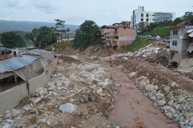

The Himalayan region is one of the world’s most environmentally sensitive mountain systems, stretching across several countries and supporting millions of people through rivers, agriculture, tourism, forests, hydropower, and other livelihoods. At the same time, its steep terrain, fragile geology, rapidly changing weather patterns, and exposure to earthquakes and glacier-related hazards make many communities vulnerable to natural disasters.
Floods and landslides are not new to the Himalayas. Seasonal rainfall has always shaped mountain landscapes, while rivers regularly carry large volumes of water from high elevations toward downstream settlements. However, the growing concern is the interaction between multiple hazards and the difficulty of predicting exactly when and where they will affect communities. The Hindu Kush Himalaya has experienced a range of recent multi-hazard events, including floods, landslides, glacial lake outburst floods and debris flows.
In this environment, early-warning systems have become an increasingly important part of disaster preparedness. Their purpose is not to prevent a flood or landslide from occurring. Instead, they are designed to provide people with enough information and time to take protective action.
The central lesson emerging from Himalayan disaster management is that an early-warning system is most useful when technology, scientific information, local knowledge, communication networks, government preparedness, and community participation work together.
Why Himalayan Communities Face Multiple Risks
The geography of the Himalayas creates a complicated disaster-risk environment. Steep slopes can accelerate water movement during intense rainfall, while loose rock and soil can become unstable when saturated. Rivers can rise quickly, particularly in smaller mountain catchments where communities may have little time to respond.
The region is also exposed to hazards originating at high elevations. Glacial lake outburst floods, avalanches, landslides, debris flows, and sudden changes in river discharge can affect communities far downstream. A hazard that begins in a remote mountain valley can therefore become a major threat to settlements, roads, bridges, farms, and infrastructure at lower elevations.
Climate variability and long-term warming add another layer of uncertainty. Scientific research on Himalayan flood-warning systems has emphasised that extreme rainfall and changing hydrological conditions can increase vulnerability, while highly localised rainfall patterns can make broad-scale datasets less reliable for understanding individual mountain watersheds. A 2026 study in Natural Hazards and Earth System Sciences found substantial spatial variation in rainfall across the Bindal watershed in Uttarakhand and highlighted the value of local monitoring for understanding flash-flood dynamics.
This means that communities cannot depend on a single source of information. Effective preparedness requires multiple forms of observation and communication.
Understanding the Difference Between a Hazard and a Disaster
A flood or landslide is a natural hazard, but it does not automatically have to become a disaster. The consequences depend partly on where the hazard occurs, how many people are exposed, how vulnerable infrastructure is, and whether communities have the ability to respond.
A flood passing through an uninhabited area may cause environmental changes but limited human loss. The same flood reaching a densely populated settlement can become devastating.
This distinction is important because disaster preparedness is not solely about predicting natural events. It is also about reducing exposure and vulnerability.
For Himalayan communities, this can involve land-use planning, safer infrastructure, protection of evacuation routes, community preparedness, slope monitoring, river monitoring, emergency communication, and public awareness. Early-warning systems become one component of this larger risk-management process.
What an Early-Warning System Actually Does
An early-warning system is often imagined as a siren or an emergency message on a mobile phone. In reality, an effective system involves several connected stages.
First, authorities and communities need knowledge about the hazards affecting an area. Monitoring systems then collect information about rainfall, river levels, slope conditions, weather, glaciers, or other relevant indicators. That information needs to be analysed so that potentially dangerous conditions can be identified.
The warning then has to reach the people who may be affected. Finally, those people need to know what the warning means and what action they should take.
This last stage is particularly important. A technically accurate warning is of limited value if residents receive it too late, cannot understand it, do not trust it, or have nowhere safe to go.
ICIMOD’s work on community-based flood early-warning systems emphasises risk knowledge, community monitoring, communication, and response capability as interconnected components of an effective system.
The Importance of Local Monitoring
One of the most important lessons from Himalayan flood research is that local conditions matter.
Mountain watersheds can experience significant differences in rainfall over relatively short distances. A weather station located several kilometres away may not accurately represent conditions in a particular valley or tributary.
The 2026 Uttarakhand study demonstrated this challenge by recording pronounced spatial differences in rainfall within the Bindal watershed. The researchers found that local observations captured rainfall variability that larger secondary datasets did not fully represent.
This does not mean that satellite data, weather models, or regional forecasting systems are unhelpful. Instead, it demonstrates the value of combining large-scale information with local observations.
Rain gauges, river-level sensors, weather stations, remote sensing, satellite imagery, and community observations can complement one another. Together, these sources can provide a more detailed understanding of rapidly changing conditions.
Community-Based Early-Warning Systems
Technology becomes more effective when local communities are involved in the warning process.
ICIMOD has developed community-based flood early-warning approaches in which upstream communities monitor river conditions and communicate information to downstream communities. Such systems can use relatively simple instruments combined with mobile communication and local responsibilities.
The principle is straightforward. People living closer to the source of a flood may observe rising water earlier than communities downstream. If they can communicate this information quickly, downstream residents may gain additional time to move people, livestock, documents, equipment, or other essential belongings to safer locations.
One documented ICIMOD example in the India-Nepal border region reported that a community-based system provided people with several hours of additional preparation time before flooding. The experience highlighted that the value came not only from the technology but from involving local people and government agencies in the warning process.
This approach is particularly relevant in areas where sophisticated monitoring infrastructure may be difficult or expensive to install across every small river and settlement.
Warnings Must Lead to Action
A warning is only one part of disaster preparedness. Communities also need a response plan.
If residents receive an alert about rising water but do not know where to go, the warning may not translate into effective action. Similarly, an alert about a possible landslide is less useful if evacuation routes are unknown or blocked.
Communities therefore need to connect warnings with practical preparedness. Evacuation locations, safe routes, emergency contacts, transportation arrangements, shelters, and procedures for assisting vulnerable residents should be understood before a disaster occurs.
This is particularly important in mountain areas because roads and bridges can themselves be damaged during floods and landslides. A route that is normally safe may become unusable during an emergency.
Preparedness therefore needs to consider multiple scenarios rather than relying on a single evacuation plan.
Communication Is as Important as Detection
Modern technology provides many ways to distribute warnings, including mobile phones, SMS, applications, radio, sirens, public-address systems, television, social media, and local communication networks.
However, the most advanced communication system is not automatically the most effective. Remote mountain communities may experience weak mobile connectivity or electricity disruptions during severe weather. A warning strategy should therefore avoid depending entirely on one communication channel.
Messages also need to be understandable. People should know whether a warning means they should remain alert, prepare to evacuate, or immediately move to a safer location.
ICIMOD’s community-based systems emphasise that warning information needs to be disseminated rapidly and clearly to the people who are at risk.
The lesson is simple: the final stage of an early-warning system should be designed around the person receiving the warning, not only the technology generating it.
Landslides Require a Different Kind of Preparedness
Flood early-warning systems can often monitor variables such as rainfall and river levels, but landslide prediction can be more complicated.
A landslide may depend on slope geology, soil moisture, rainfall intensity, terrain, vegetation, previous disturbances, earthquakes, drainage conditions, and other factors. Some slopes may remain stable under conditions that cause failure elsewhere.
This makes landslide preparedness particularly dependent on hazard mapping and local knowledge. Communities can benefit from identifying historically unstable slopes, observing changes such as cracks or unusual drainage, and understanding which roads or settlements may be exposed.
Monitoring technologies such as remote sensing, ground-based instruments, rainfall measurements, and satellite imagery can contribute to risk assessment. But technology should complement rather than replace field observations and local knowledge.
The Role of Artificial Intelligence and Remote Sensing
New technologies are creating additional possibilities for disaster-risk management.
Satellite imagery can help monitor changes in terrain, glaciers, river systems, and land cover. Remote-sensing technologies can provide information across large and difficult-to-access areas. Artificial intelligence and machine-learning models can also be used to analyse large datasets and identify patterns associated with hazards.
However, AI-based systems should not be treated as perfect prediction machines. Mountain environments contain complex processes, and models depend on the quality and availability of data.
The 2026 Himalayan flood research demonstrates why this matters. Researchers found that local monitoring captured important rainfall characteristics that some larger datasets did not adequately represent.
The future of disaster technology is therefore likely to involve combining AI, satellite observations, sensors, weather forecasts, hydrological models, and local measurements rather than relying on one technology alone.
India’s Multi-Hazard Warning Approach
India has been developing and using multi-hazard warning capabilities that combine observations, forecasting models, geographic information systems, and telecommunications.
According to the Ministry of Earth Sciences, India’s Multi-Hazard Early Warning System includes observational networks, forecasting models, and a GIS-based decision-support system for monitoring and communicating information about hazards such as heavy rainfall. The Central Water Commission also issues short-range flood forecasts at identified locations, including in Himalayan states such as Uttarakhand.
Such systems demonstrate the importance of connecting national scientific infrastructure with local preparedness.
However, a national warning can only reduce risk if information travels effectively through the final stages of communication and reaches people who can act on it. This is why local administration, community organisations, volunteers, schools, emergency services, and residents remain important parts of the wider warning chain.
Cross-Border Cooperation Matters
Himalayan rivers and mountain systems do not follow political boundaries. A rainfall event or flood originating in one area can affect communities downstream in another administrative region or country.
This creates a strong case for regional cooperation. Countries sharing Himalayan river systems can benefit from exchanging hydrological information, weather observations, hazard data, forecasting information, and lessons from previous disasters.
ICIMOD has repeatedly highlighted the importance of regional cooperation and people-centred early-warning systems across the Hindu Kush Himalaya.
Regional collaboration is particularly important for hazards that develop upstream but create impacts downstream. Information sharing can potentially increase the time available for downstream communities to prepare.
Early Warnings Must Include Everyone
Disaster warnings are most effective when they account for the needs of the entire community.
Children, older people, people with disabilities, people living alone, people without smartphones, and households in remote locations may face different challenges during an emergency. Language and literacy can also influence how warnings are understood.
Women and economically vulnerable households may face additional barriers in accessing information, transportation, or safe shelter. Early-warning systems should therefore be designed to reach diverse groups rather than assuming that every resident has the same access to technology and mobility.
People-centred disaster management means asking whether the warning actually reaches those most at risk and whether they have the resources necessary to act on it.
Infrastructure and Early Warning Must Work Together
Early-warning technology cannot compensate for unsafe infrastructure or poorly planned development.
If roads are built in highly exposed areas, settlements expand onto unstable slopes, drainage systems are inadequate, or bridges lack sufficient resilience, warnings may reduce some losses but cannot eliminate the underlying risk.
Risk-sensitive planning therefore needs to accompany early-warning investment.
Infrastructure projects in mountain regions can benefit from considering slope stability, drainage, flood pathways, changing rainfall patterns, and potential cascading hazards. Protecting natural drainage systems and maintaining slopes and watersheds can also contribute to broader resilience.
The objective should be to reduce risk before an emergency rather than relying entirely on emergency response afterward.
From Disaster Response to Disaster Preparedness
Historically, disaster management has often focused heavily on rescue, relief, and rebuilding after an event. These activities remain essential, but early-warning systems encourage a stronger emphasis on preparation.
If a community receives a reliable warning several hours before a flood, it may have time to evacuate residents and livestock, protect important documents, move vehicles, close vulnerable infrastructure, and prepare emergency shelters.
Even a short increase in preparation time can make a difference.
This is why early-warning systems should be viewed as investments in resilience rather than simply technological projects. Their value is measured not by the number of sensors installed but by whether communities can make safer decisions before a hazard causes widespread damage.
Learning From Recent Himalayan Disasters
Recent events across the Hindu Kush Himalaya have demonstrated that disasters can involve several interacting hazards rather than a single predictable event. ICIMOD’s 2026 regional disaster-risk initiative highlighted recent incidents including the Melamchi flood, Chamoli disaster, South Lhonak glacial lake outburst flood, Thame GLOF, Rasuwa-Kerung glacier discharge and debris flood, and compound flood and landslide events in Nepal.
These events reinforce the need for multi-hazard preparedness.
A community may prepare for heavy rainfall but still face a landslide. A flood may damage the road needed for evacuation. A glacier-related event may create sudden downstream flooding. An earthquake can alter slopes and increase later landslide risks.
Disaster planning therefore needs to recognise that one event can trigger another.
Building a More Resilient Himalayan Future
The future of Himalayan disaster preparedness will depend on combining scientific knowledge with local experience.
Better monitoring can improve understanding of rainfall, rivers, glaciers, and slopes. Improved forecasting can provide earlier information. Digital communication can distribute alerts rapidly. Community-based systems can ensure that warnings reach people on the ground. Local preparedness plans can convert information into action.
The key is integration.
A sensor without communication has limited value. A warning without an evacuation plan has limited value. An evacuation plan without accessible routes has limited value. Technology without community trust can also fail.
Resilience is therefore created through a chain of connected capabilities.
Conclusion
Floods and landslides will remain part of life in the Himalayan region, but their consequences are not entirely predetermined. Communities, governments, researchers, and technology providers can work together to reduce vulnerability and improve preparedness.
The strongest lesson from Himalayan early-warning experience is that technology should serve people. Local monitoring, scientific forecasting, mobile communication, satellite observations, community knowledge, emergency planning, and regional cooperation all have roles to play.
Recent research from the Himalayas also shows why local conditions matter. Rainfall can vary significantly across short distances, and systems designed around broad regional information may not always capture the details needed for flash-flood preparedness.
For Himalayan communities, the future of disaster preparedness is therefore unlikely to depend on a single device or prediction model. It will depend on building connected systems in which accurate information reaches the right people at the right time and is linked to practical action.
An effective early-warning system is ultimately more than an alert. It is a bridge between scientific knowledge and community decision-making. When that bridge is strong, even a short period of advance information can give people an opportunity to prepare, move to safety, protect livelihoods, and reduce the human cost of a disaster.
Online Internship with Certificate
You may be interested

Why Internal Disagreements Within Constitutional Institutions Matter to Public Trust
Anshika Jain - Oct 14, 2026Constitutional institutions are the foundations of a democratic system. They establish the rules through which public power is exercised, protect citizens' rights, oversee elections, interpret laws and…
When Police Try to Close a Case: What Legal Remedies Can Victims and Families Pursue?
Anshika Jain - Oct 14, 2026For victims of crime and their families, registering a police complaint is often the first step towards justice. They may provide statements, submit documents, identify witnesses and…

Murder Case: Court Sentenced Muskan Rastogi and Sahil Shukla to Death
Anshika Jain - Oct 14, 2026The Meerut blue drum murder case has become one of India's most widely discussed criminal cases because of the circumstances surrounding the killing of Saurabh Rajput, the…
Most from this category
Journalists Detained During Protests: Police Authority End and Press Freedom Begin?
Anshika Jain - Oct 14, 2026

Politics of Protest Bans: Balancing Public Order With the Right to Demonstrate
Anshika Jain - Oct 14, 2026

Journalists Detained During Protests: Police Authority End and Press Freedom Begin?
Anshika Jain - Oct 14, 2026Why Are Young Indians Protesting Against Voter-List Revisions?
Anshika Jain - Oct 14, 2026Politics of Protest Bans: Balancing Public Order With the Right to Demonstrate
Anshika Jain - Oct 14, 2026